A GARDENER’S LOOK AT THE CLIMATE IN NORTH CAROLINA BACKYARDS: HISTORY OF CLIMATE STUDIES AND PIEDMONT REGION CLIMATE — 2021 UPDATE
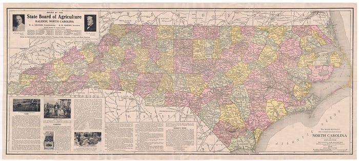
This is the annual update to last year’s article, A GARDENER’S LOOK AT THE CLIMATE IN NORTH CAROLINA BACKYARDS: WAKE COUNTY, PIEDMONT REGION — 2020. While the article’s background, history of climate change studies in North Carolina and how gardeners can themselves access online climate tools remain, climatic records and observations have been updated to include 2021 data.
The researched based conclusions remain the same: All published North Carolina climate change studies have not found significant, enduring and unprecedented changes in the state’s climate to date, even though the most recent one claims some climate change is taking place and predicts changes in the future (but discussed in more detail below). In the central Piedmont region of the state, 2021 was on average a cooler year than 2020, the trend of no unusual increase in severe weather events continued, hurricanes continued their decades-old pattern of decreasing in frequency and intensity, and climatic factors important to gardeners such as average Spring and Fall freeze dates, soil temperature, humidity, growing seasons and growing degree days remain within a historically normal range.
Gardeners increasingly are being provided with information on climate change in North Carolina. However, a couple of additional perspectives are helpful: (1) input from average home gardeners about what climate and weather issues matter most to them and (2) an examination of the local climate and weather where we actually live. Presenters have warned gardeners of changes in the climate involving rising temperatures, extreme rains, more frequent and powerful hurricanes and the specter of drought. We also have been counseled not to use non-organic fertilizers, to replace our lawns, to watch out for spiders with more powerful venom and new insects in warming soils, with one presenter even suggesting gardeners stop using power tools.
This article is written for gardeners by a fellow home gardener and is meant to empower gardeners to assess and evaluate the climate in their own location. The following information will give gardeners the tools to look behind the figures if they wish to do so. These days, the information by which many observations and conclusions about the weather can be made is at our fingertips and there is no reason that gardeners cannot also be citizen scientists and figure a good number of things out for themselves.
For years I had been your average home gardener but then received intensive horticultural training and education through a state university program which emphasized making decisions, as well as giving and interpreting advice, grounded on research-based information. I was preparing a presentation on Fall gardening and managed to figure out the average first Fall and last Spring freeze dates in my hometown of Raleigh, Wake County, North Carolina. Through this process and interactions with representatives of various climate agencies, I had a peek into how climatological calculations and conclusions were made and learned that as gardeners we should always when we can trust, but verify, and support our decisions with our own research whenever possible. It also became apparent after reviewing the studies done on climate change in North Carolina that local climate variability is very significant throughout the state.
When we are told that our climate has changed and that the change is (1) significant, (2) enduring and (3) unprecedented, we want to know if real, transparent facts exist where we actually live to support these conclusions. So, this article is an examination of whether there exists in Wake County, North Carolina, and the surrounding Piedmont region, significant, enduring and unprecedented climatological trends, to examine some statewide issues such as drought and hurricanes, and, further, to examine climate issues that are of particular interest to gardeners.
WAKE COUNTY
Wake County is in the middle of the state of North Carolina and is where the state capital of Raleigh sits.
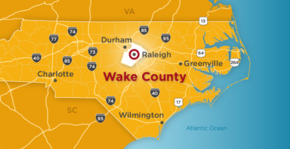
North Carolina is known to be divided into three regions, the Mountains in the West, the Piedmont region in the middle and then the Coastal area to the East. Wake County is in the Piedmont region and the weather observations reported later will be applicable to many of the surrounding areas in the Piedmont, which generally has a similar topography and climate.

HISTORY OF CLIMATE CHANGE STUDIES IN NORTH CAROLINA
First, a brief history of climate change research in North Carolina to provide a background before drilling down to the conditions in Wake County. There have been three major climate change studies in the past couple of decades.
Two leaders of the State Climate Office of North Carolina (SCONC), published a 2002 paper in Environment International titled Analysis of Climate Trends in North Carolina (1949–1998).¹ This study started off by noting that North Carolina has one of the most complex climates in the country and that most of the climate trends found were local, not statewide. The study found on a statewide basis that while temperatures in the last 10 years of the study were warmer than usual, they were not warmer than the temperatures experienced in the 1950’s. They did find that the dates between last Spring freeze and first Fall freeze had become longer and that precipitation had increased during the study period for the Fall and Winter seasons but had decreased during the Summer and remained the same for Spring. Maximum temperatures had remained fairly constant and there was no widespread pattern showing increasing minimum temperatures across the state.
Mention should also be made at this point of a 2010 report titled “Final Report to the General Assembly and the Environmental Review Commission” prepared by the Legislative Commission on Global Climate Change. While this report generally discussed global climate change issues and made various recommendations it did not present any studies of long-term climate trends throughout the state nor any conclusions as to whether North Carolina had been experiencing any long-term trends reflective of global warming.²
2015 Climate Change in North Carolina Report
This report, by the State Climate Office of North Carolina, looked at a much longer time period, investigating records back to the late1800’s.³ The report found no warming trend in the 113-year study period starting from 1895. While there was some warming since the mid-1970’s, it was found to be not unprecedented and similar to the warming observed from 1910–1950. The 2015 SCONC report stated that in North Carolina there is “no meaningful trend that is associated with global warming.”
Interestingly, while the report noted a rise in minimum temperatures, this was only in urban areas and was not found in rural areas. The report concluded that possibly was due to urban development, but it was not due to global warming. The report also found no meaningful trends in precipitation and that there had not been more frequent or longer droughts in modern times. The SCONC summed up its view on climate change in 2015 by pointing out that it also had analyzed dozens of other temperature data “(including seasonal patterns, days with extreme high and low temperatures, a variety of temperature thresholds, degree days, growing season data, frost data), and one common thread joined them all: “… the trends are generally flat …” The State Climate Office concluded that, “… local climate variability is so high in North Carolina that significant trends are difficult to deduce.”
The State Climate Office of North Carolina removed this report from its website after a change in Directors.
2020 Climate Study — North Carolina
This study was done in response to an order of the new Governor of North Carolina after his 2016 election.⁴ The above prior climate change studies were not mentioned in the study, nor is there any mention of the history of climate changes studies in the state. The study addressed climate issues statewide, and also in the three main regions of the state, Western Mountains, the Piedmont and the Coastal Plain. The 2020 study’s conclusions as to climate trends for the entire state ambiguously included, as to average annual temperatures, that recent temperatures had increased statewide “about” 1° since 1895 (but nowhere in the report is the actual figure reported nor use of the word “about” defined). Further, it is not made clear whether this “about 1°” figure was compared to the existing average annual temperature in 1895 or compared to the average annual temperature for all the years since 1895.
Reference to the study’s charts and graphs does not assist with this issue because in a confounding twist, the 2020 study acknowledged that it used a different data set for all of its graphics depicting temperatures and precipitation. Instead of using the dataset from which it obtained its climate information (“NOAA’s National Centers for Environmental Information (NCEI) Climate Divisional Dataset (nClimDiv), version 2.”), it instead turned to a different data set for its charts and graphs, “NOAA NCEI’s Global Historical Climatology Network-Daily (GHCN-D), version 3.” The study did not explain how it used climate information from one dataset for its conclusions, but then used data from a different data set to illustrate these conclusions in its graphs and charts. As to use of the GHCN-D network, however, NOAA acknowledges that two-thirds of the stations in this network only record precipitation. NOAA further states that anyone using this dataset should also cite a published article which found, according to NOAA, that, “In general, the stations providing daily observations were not managed to meet the desired standards for climate monitoring. Rather, the stations were deployed to meet the demands of agriculture, hydrology, weather forecasting, aviation, etc.” [⁴a] The 2020 study did not cite this article.
In any event, given the specific scope of this article, that is, Wake County and the surrounding Piedmont area, reference will be made to the 2020 study’s conclusions regarding the Piedmont.
Of the 14 climate categories examined by this study related to the outdoor environment which could affect gardens, only two significant trends in the Piedmont were noted: (1) an increase in the average temperature from an undetermined time in the 1990s (while noting a similar increase in the 1930s — 1950s), and (2) days per year with minimum temperatures of 75° having increased since 2005 (while again noting a similar increase in the 1930s — 1950s). Heating Degree and Cooling Degree Days, which are used to quantify the energy needed to heat or cool buildings and houses, were found to vary over time in concert with the area’s annual average temperature and are not addressed in this article.
The study found very hot days (95° or higher) decreasing and the number of cold days (32° or lower) with no overall trend but increasing since 2014. The study found no long-term overall trends in the Piedmont in annual hottest temperatures, annual precipitation, extreme precipitation (days with 3 or more inches of rain), drought, and no overall historical trends in ice storms, tornadoes and thunderstorms. The study did reference an increase in annual coldest temperatures (based on an historical simulation method for an abbreviated period of 1970–2005) and decreasing snowfall but only as of 2007. The study did not address the history or future of hurricane impacts in the Piedmont region section of the report.
The 2020 study contains long range predictions which reach 60–80 years into the latter part of this century. The study projects significant changes in the Piedmont for each of the climate categories examined except for ice-storms and winter storms. However, the State Climate Office of North Carolina noted in its 2015 report that the climate models of the Intergovernmental Panel on Climate Change (“IPCC,” the lead United Nations body on climate change) had predicted warming over the past 50 years but which had not occurred. The SCONC concluded that, “Unfortunately, the best global climate models we have do not do a good job of simulating the temperature and precipitation patterns over the southeastern US, and NC in particular.”³
QUALITY AND RELIABILITY OF WEATHER STATIONS
The quality and reliability of the weather observation stations used when determining historical weather records in these climate change studies should be examined so that the average gardener knows what kind of weather data is being relied upon. The 2020 study notes that it included and relied on the use of so-called “COOP” stations. There generally are three kinds of weather stations in descending order of quality, First Order (also known as Primary), Secondary and then COOP. First Order stations are those of the highest quality and reliability. They are monitored by professionals and reliably record hourly (and even sub-hourly) observations and are subject to additional and more rigorous quality checks than all other stations. As explained by a representative from the National Oceanic and Atmospheric Administration (“NOAA”): “When it comes to station quality, NOAA NCEI First Order stations are about as quality as it comes across the U.S. There are about 500 stations, mainly major airports, that are considered First Order sites, including KRDU [the Raleigh-Durham Airport]. These sites often have more instrumentation and include more data when ordering official data from NCEI. Typically, these stations are a part of the Automated Surface Observation System (ASOS).” (“NCEI” = National Centers for Environmental Information).⁵
COOP stations (part of a Cooperative Observer Program), while more numerous, are monitored by volunteers (such as a homeowner with a station placed on his/her property) which can result in gaps in weather data records. While volunteer COOP observers can play an important role in providing weather information for forecasting and basic weather information, periods of missing weather recordings can preclude reliance on them in determining long term trends at a particular site.
While there exists a complex system of quality adjusting to take into consideration the vagaries of the COOP stations, nonetheless, none of the three North Carolina climate change studies discloses whether any minimum station quality qualifications and criteria were employed or whether any COOP stations were disqualified from use. There exists a First Order station in Wake County and the surrounding Piedmont area at the Raleigh Durham International Airport (RDU, also referred to in weather records as “KRDU”).
As gardeners, we like to get down to ground level, so let’s take an actual look at some local First Order and COOP stations in Wake County.
Here is an aerial shot of the installation that includes the First Order weather station at RDU (id #13722)⁶:

It has been in place since 1944 and is professionally managed and monitored, while recording hourly and sub-hourly observations. It has a 100% record of days recording and reporting the weather data discussed in this article. It presently records 95 weather parameters. Through NOAA’s ThreadEx program⁷, historical weather observations from 1887 by its predecessor station are included in the weather records provided.⁸ Examination of climatic records at weather stations in the ThreadEx program are an accepted, recognized method of assessing regional climate trends in the United States.⁹ Among all weather stations in the state, NOAA has designated RDU as one of only six “Primary Local Climatological Data Stations” for North Carolina.¹⁰ These stations are regarded as “Primary” because of the extensive and manual quality control checks they are subject to, which other weather stations are not.¹⁰
For a related article which compares recent temperatures to historical temperatures at these six Primary weather stations , see: https://tpacker25.medium.com/north-carolinas-climate-and-it-s-six-primary-weather-stations-c1bccd68d905?source=friends_link&sk=648bfd8dff860d60b37dd7beca16a5d5
On the other hand, here is an image of a COOP weather station, (id #311535), located in Cary, North Carolina:

It is located in the front yard of a home in a residential neighborhood in Cary and with temperature observations beginning in just in 2001. It monitors three weather conditions, temperature, precipitation and snowfall. It is reported as missing 335 days of temperature observations.¹¹
This is the Falls Lake Weather COOP station (id #312993). It is in the backyard of a home in a residential neighborhood.

A closer look reveals that it is a weather apparatus manufactured by the Davis instruments company which can be purchased online.
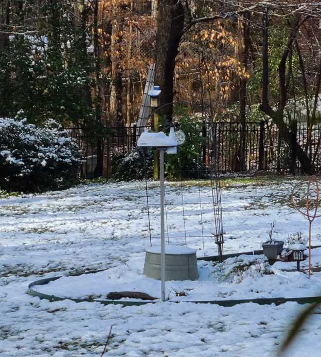
This station has been in use just since 2000 and is reported to have 505 missing days of temperature data in its average temperature reports.¹²
Here is the list of COOP stations in Wake County as provided by NOAA.¹³
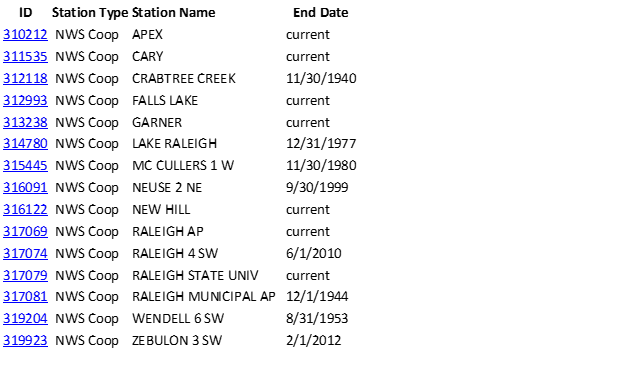
Of the 14 COOP type weather stations in Wake County¹⁴, six have not been functional this century and three stopped functioning in 2010, 2012 and 2022. Of the remaining five stations, three stations have start dates since 2000 and one since 1993.¹⁵ So, for example, three stations with only 20 years of weather data, and missing hundreds of days of data, presumably were included in the calculations by prior climate change studies to determine whether there have been climate changes since 1895. However, NOAA’s clear and unambiguous guidance is that when trying to determine what the climate is like during a period of time (what NOAA refers to as a “climate normal”) at least 30 years of weather observations should be used. Lastly, unlike the RDU First Order station in Wake County, none of these Wake County COOP stations have an uninterrupted report of complete climate records from 1887.
In other contexts, COOP stations only have been used if they meet minimum criteria. For example, in determining the annual minimum temperatures for their Plant Hardiness Zones, the United States Department of Agriculture (USDA) only used COOP stations if they had low temperature recordings at least 80% of the time in the cold months and for a minimum number of years.¹⁶ NOAA’s use of at least 30 years of data is longstanding and based on the instructions of almost a century ago by the International Meteorological Organization to calculate climate normals by using 30-year periods. NOAA also relies on the general rule in statistics that at least 30 numbers are needed to obtain a reliable estimate of their mean or average.¹⁷
Additionally, the USDA has stated that at least 50–100 years of data of overall average temperatures are needed to assess changes in the climate.¹⁸ Using COOP stations with only a few recent years of incomplete observations, or even using older stations yet with significant incomplete records, dilutes the purity of the historical observations, particularly when examining a regional area such as the Piedmont and where higher quality, First Order weather stations with a long history of non-missing data exist.
While most studies and reports on weather and climate issues do not identify the individual weather stations involved, sometimes they are identified when reporting, for example, freeze dates in particular localities. If so, for the home gardener, the reporting history of any weather station can be searched at: http://xmacis.rcc-acis.org, which is supported by the NOAA Regional Climate Centers.¹⁹ Details of an individual station history such as maintenance, location and other items can be found by going to NOAA’s Historical Observing Metadata Repository at https://www.ncdc.noaa.gov/homr/# and entering the station id number or using the search function to find it.
EXAMINATION OF WEATHER DATA FROM FIRST ORDER WEATHER STATION RDU
The following will examine the historical weather data as reported and maintained by NOAA’s climate records for the weather station located at RDU and its NOAA selected predecessor station. Importantly, some of the categories are additional to those examined in prior climate change studies in order to be more directly relevant to gardeners, for example, humidity, average frost dates, growing season, soil temperature (using two stations other than RDU) and growing days.
AVERAGE TEMPERATURE
The average temperature in 2021 was .8° cooler than in 2020 (61.8° v. 62.5°) The average temperature reported at RDU since 1887 is 60.11°.²⁰ This can be broken down by decade as follows:
1887–1891: 59.64°
1892–1901: 59.81°
1902–1911: 59.99°
1912–1921: 60.18°
1922–1931: 60.61°
1932–1941: 61.21°
1942–1951: 60.19°
1952–1961: 59.51°
1962–1971: 58.34°
1972–1981: 59.00°
1982–1991: 60.00°
1992–2001: 59.97°
2002–2011: 61.20°
2012–2021: 61.67°
A cool, warm, cool, warm trend through the decades can be seen by viewing these numbers and this chart:

In the last three decades since 1992 the average temperature has been 60.94°, a .83° increase above the historical average. This can be compared to another warming period in the first half of the last century, namely the average temperature in the 30-year period from 1922–1951, which was 60.67° (.56° above the average), and which reflects just a .27° difference between these two 30-year periods. So, the average temperature for the past 30 years is not unprecedented. The five warmest decades since 1887 have been (1) 2012–2021, (2) 1932–1941, (3) 2002–2011, (4) 1922–1931 and (5) 1942–1951. As far as the warmest average temperature year on record, it is a tie between 1933 and 2017 at 62.7°.
Climate records from the 1950’s and before are deemed significant by the climatic research community as they occurred during a pre-industrial period reflective of natural (that is, non-manmade) climate conditions. As the lead author of the 2020 North Carolina Climate Study wrote, “Because industrial development was minimal until about midway through the 20th Century, the earlier record reflects mainly natural variability.”²¹
The 2020 North Carolina Climate Change study made references to this earlier warming period, but only compared the single 10-year time-period of 2009–2018 with another single decade, 1930–39. The report found a difference of “about 0.6°” but then moved on without further comparisons with other prior temperature phases in the 1800’s or 1900’s. However, as discussed above, NOAA recommends when comparing climate normals from periods of time to use at least 30-year, not 10-year, periods¹⁷, and as the lead author of the 2020 climate study points out, temperatures from the mid-20th century and before reflect non-manmade climate patterns to compare against more modern climate observations and patterns.

AVERAGE MINIMUM TEMPERATURES
The average annual minimum temperature at RDU from 1887 to 2021 was 49.67°.²² The last 30 years since 1992 the average has been 50.13°. The average annual minimum temperature from 1912–1941 was 51.06°. The highest five decades of average annual minimum temperatures have been (1) 1932–1941, (2) 2012–2021, (3) 1922–1931, (4) 1912–1921 and (5) 1892–1901.
It is clear that the past 30 years of average minimum temperatures in our area in the Piedmont are not unprecedented and are lower, or colder, than another 30-year period about century ago, from 1912–1941. Here is the chart reflecting these figures.
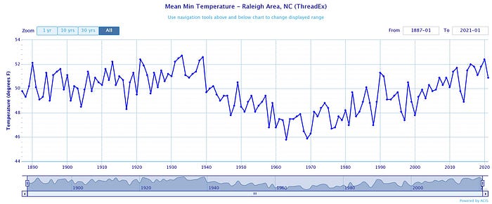
So, while minimum temperatures have been rising somewhat the past three decades, they were appreciably higher in the first few decades of the last century.
AVERAGE MAXIMUM TEMPERATURES
The average annual maximum temperature since 1887–2020 has been 70.54°.²³ The last 30 years since 1992 the average annual maximum temperature has been 71.75°, a 1.21° increase over the historical average. The average annual maximum temperature from 1932–1961 was 70.98°, a .44° increase over the average, thus again revealing that a 30-year period, or “climate normal,” from nearly 100 years ago also had higher than average maximum temperatures.
This is the related chart.

In sum, the above three averages show that for the last three decades, the average temperature has risen, but similar to a like period in the last century, the average minimum temperatures are almost a full degree colder than a similar period last century, while the average maximum temperatures have risen but a similar 30-year period in the mid-20th century also had average maximum temperatures higher than the historical average.
MINIMUM DAILY TEMPERATURES EQUAL TO OR ABOVE 75°
Before leaving the basic temperature observations, let’s take a look at the trend described by the 2020 climate change study of an increase in daily minimum temperatures equal to or greater than 75° since 2005, but with a well-above average spike in these types of days in the initial study period of 1900–1904. The study published a graph to illustrate this but notes that the figures used are from three sources, “NCICS (North Carolina Institute for Climate Studies), NOAA NCEI (National Centers for Environmental Education) and the State Climate Office of North Carolina” without explanation as to whose numbers were used, what numbers were used, whether they were combined, or in general how they were compiled.
In any event, the corresponding numbers from the First Order weather station in Wake County at RDU, shows that since 1887 there have been on average 2.81 days a year with the minimum temperature equal to or greater than 75°. There were 4.00 such days on average per year from 1912–1941 and 4.46 such days on average per year from 1992–2021.²⁴
As can be seen from the below graph, years with 10 or more days of 75° minimum temperatures (also referred by some presenters as “warm nights”) have been occurring for all of the weather reporting history, but with four spikes since 2005, while also including several years since then under the long-term average.

❗️
Before leaving this category, keep in mind that in 2015 the State Climate Office of North Carolina specifically found in its Climate Change in North Carolina report that while noting a trend of higher minimum temperatures (which it defined using the term “morning lows), this only was found in urban, not rural areas. The report concluded that this was a result of urbanization of North Carolina’s cities and “was not evidence of any impact from greenhouse gases and global warming to North Carolina’s climate.”³ The 2020 study ignored this previously reported urban/rural issue involving a trend in higher minimum temperatures and did not address it.

RAIN
The average annual rainfall at RDU since 1887 is 44.97” a year.²⁵ Rainfall in 2021 totaled 45.25 inches, compared with 55.19 inches in 2020.
The last 30 years have averaged 46.37” a year. The 30 years from 1922–1951 had an annual average of 45.54” a year.
Here is the corresponding chart.
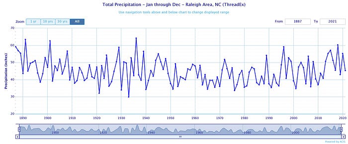
The above shows that there has been no recent significant, enduring and unprecedented trend in average annual rainfall. However, there have been cautions about an increased incidence of “extreme’ rainfalls so, let’s examine that issue.

“EXTREME” RAINFALL
Extreme rainfall is defined by the 2020 Climate Change report as when it rains three or more inches a day. This type of event could affect our gardens resulting in flooding, standing water, excessive moisture and plant trauma. Even though the 2020 report did not find any trends of significance involving extreme rainfall in the Piedmont region, let’s examine our rainfall patterns nonetheless.
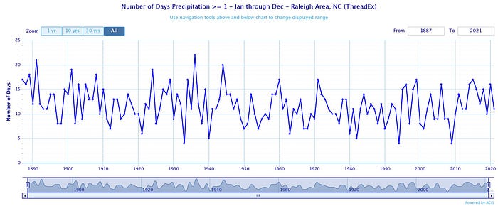
1” RAINFALL EVENTS
The average number of days per year with 1 or more inches of rainfall since 1887 at RDU is 11.74.²⁶ In the last 30 years the average has been 11.7 days per year. From 1912–1941 the average was an identical 11.7 days.
Here is the related chart.
2” RAINFALL EVENTS
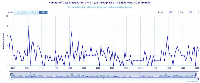
The average number of days a year in which it rains 2” or more at RDU since 1887 is 2.2 days.²⁷ For the last 30 years the number is 2.36 days. The average for 1932–1961 was 2.33 days.
Here is the related chart.
3” OR MORE OF RAIN A DAY
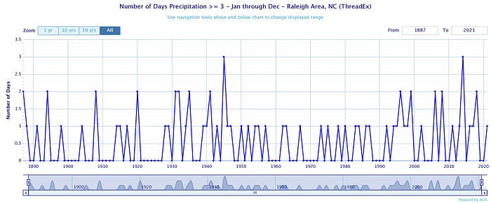
It has been said that the number of days of “extreme” rain events of 3” or more a day had, and would, increase. Presenters referenced the heavy rainfall effects of Hurricane Matthew in 2016 (the effects of hurricanes to be discussed a bit later). While we all can recall the slow moving, swollen rivers after Matthew, according to the 2020 North Carolina Climate Change report⁴ , no trend of an increasing number of extreme rain events has been found in the Piedmont. It can also be mentioned that the Matthew rainfall was the only extreme rainfall event in the Piedmont in 2016.
The average number of days a year since 1887 it has rained 3” or more is .54.²⁸ The past 30 years has seen an annual average of .80 such days. There was a 30-year period from 1931–1960 when the average was .73 days. There has been only one such event the past three years. The 2020 NC Climate Change study found no trend in the Piedmont region relating to these types of extreme rains.
Here is the related chart.
SNOWFALL
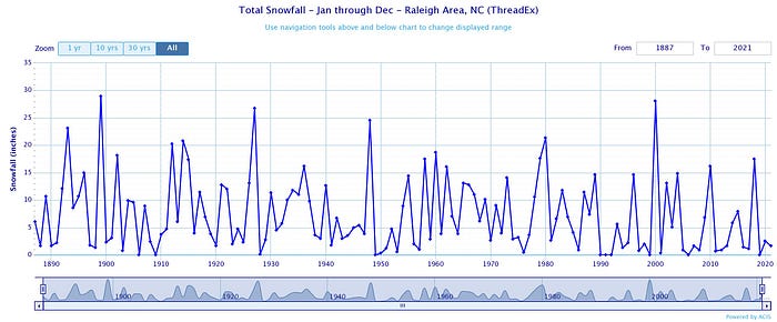
The average annual snowfall reported at RDU is 7.15”.²⁹ The average for the last 30 years shows a decrease to 5.17”. The average for the 30-year period from 1932–1961 was 7.11”. The three highest snowfall decades are (1) 1892–1901: 10.70”, (2) 1912–1921: 10.51” and (3) 1922–1931: 9.76”. The three lowest snowfall decades are (1) 2012–2021: 4.04”, (2) 1942–1951: 5.34” and (3) 1902–1911: 5.45”.

NUMBER OF SNOW DAYS PER YEAR
The average number of days it snowed per year over recorded RDU history since 1887 is 3.73.³⁰ The average number of snow days per year for the past 30 years is 3.33.³⁰ The average number of snow days per year for the 30-year period of 1922–1951 was an identical 3.33.
Here is the related chart.
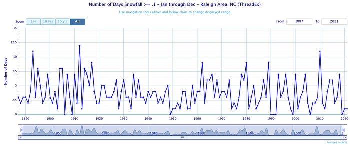
The above data reflects that no meaningful trends appear with respect to snow days.

HUMIDITY
A review of the relative humidity observations at RDU reveals that there is no observable trend of increasing humidity. North Carolina climate change studies have not addressed whether humidity is increasing or not, perhaps because not all weather stations in the COOP network report on humidity.
The average annual relative humidity since 1948 (the first-year reports on humidity are available) is 69.99. The average annual relative humidity in the past 30 years is 69.46.³¹ Thus, there are no trends as far as humidity is concerned in the Piedmont region of North Carolina.

SOIL TEMPERATURE
None of the previous North Carolina climate studies looked at soil temperatures. However, a presenter at a gardening lecture stated that due to warming temperatures a type of plant-parasitic worm (nematode) was migrating into warming soils in Wake County.
According to NOAA, there are two sources of soil temperature records in North Carolina, (1) the USDA Natural Resources Conservation Service, National Water and Climate Center and (2) the State Climate Office of North Carolina. However, the USDA source only has one station gathering soil temperature information and it is located in a far eastern part of the state in Plymouth, Washington County, and has only been reporting soil temperatures since 1994.
The State Climate Office of North Carolina, however, operates two weather stations in Wake County reporting on soil temperatures, the Lake Wheeler Road Field Lab and the Reedy Creek Field Lab. According to the SCONC these “ECONet” type stations are the only source of monitored and reported soil temperature recording data in the state.³² The Lake Wheeler station has been reporting soil temperatures since 1982 while the Reedy Creek Lab has been reporting them since 2001. However, each has many missing time periods. For example, Lake Wheeler is missing observations from 1992–1999, as well as having incomplete records for the period of 2000–2005. Reedy Creek also has intermittent missing information.³³ These significant missing periods of time prevent a clear and credible analysis of soil temperatures over a relevant and useful period of time.
However, since soil temperatures are so important to gardening, let’s at least take an informal, even if not scientifically reliable, look at the charts of the average annual soil temperatures at these two stations based on the information available (the severe dips to the bottom in the chart lines reflect missing data).

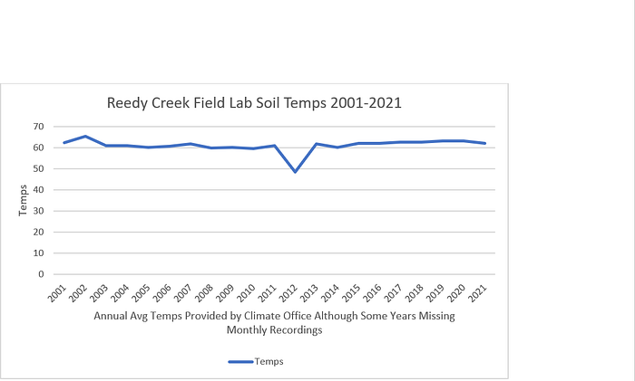
As can be seen from the above charts to the extent there is available soil temperature data, it has been fairly consistent over the years at each station.
To the extent the Lake Wheeler Road station does have the most available information, the specifics in the chart are:
1982: Missing
1983: 63.10
1984: 62.17
1985: 62.31
1986: 64.50
1987: 60.12
1988–90: Missing
1991: 65.82
1992–1999: Missing
2000: 55.65
2001: 63.25
2002: 64.50
2003: 61.81
2004: 64.32
2005: 62.45
2006: 60.71
2007: 61.05
2008: 58.65
2009: 56.05
2010: 57.30
2011: 59.11
2012: 63.70
2013: 62.01
2014: 61.01
2015: 63.09
2016: 64.41
2017: 64.45
2018: 63.60
2019: 64.95
2020: 64.14
2021: 63.30
In any event, due to the recent beginning dates of observations and the large amounts of missing data, these stations cannot be used to determine trends in soil temperatures in Wake County. Consequently, there is no long-term, reliable evidence to support an assertion that soil temperatures have warmed significantly, if at all, in our area.
DROUGHT
Both the 2015 Climate Change in North Carolina report and the 2020 NC Climate Change study did not find any long-term trends in either the Piedmont or the entire state with respect to droughts. Additionally, in the 2018 the North Carolina Department of Environmental Quality, Division of Water Resources, NC Drought Management Advisory Council Annual Report, it was stated that no clear historical trend had been seen and summarized North Carolina’s history of droughts as follows:
“North Carolina experienced extreme drought conditions from 1925 through 1927 with PDHI values reaching -4.1 at one point. A very wet period followed and then an extreme drought occurred in 1932–1933. This extreme drought period saw the lowest individual monthly PDHI value of -4.74. Occasional, moderate droughts occur in the 1940’s and 1950’s but it wasn’t until the late 1980’s that extreme drought returned. The PDHI reached a low of -4.6 in July 1986. Moderate to wet conditions returned in the 1990’s but two of the most extreme droughts in North Carolina’s recorded meteorological history occurred between 2000 and 2010. One of the wettest years also occurred during this period. Since 2010, conditions have been less extreme but highly variable swinging from moderately wet to moderately dry.”³⁴
These conclusions came along with the following chart showing the occurrences and severity of droughts in the state since 1895 to 2018.

NOAA’s National Integrated Drought Information System contains information in graphic format about the frequency and severity of droughts in specific counties.³⁵ Here is a chart of the drought history in Wake County from 1895 through 2021:

As can be seen, the dark, tall thicker red spikes reflect extreme drought conditions over time, with the last one in 2007 and not much since then and with apparent frequent and intense drought activity in the 1920s and 1930s.
The last drought of significance in memory that brought about water use restrictions to Wake County residents was in 2007. Even so, the State Climate Office of North Carolina in its 2015 report concluded that longer-term data “suggests drought periods in the past that may have been more severe than those witnessed in NC in modern times.”³ The most recent report on potential drought conditions in the state reported that from July 1, 2020 — June 30, 2021, “The past year in North Carolina has been mostly wet …,” and that statewide precipitation was the sixth wettest period since 1895 with average precipitation of 59.67 inches.³⁶
HURRICANES
Have extreme weather events such as hurricanes become more frequent and/or more powerful? Hurricanes in the past have significantly affected Wake County and the Piedmont in the past and can cause a great deal of destruction, including, from a gardener’s perspective, the toppling of trees and washing out and blowing away of gardens.
Initially, though, from an on-the ground perspective, a recently retired manager of the City of Raleigh Urban Forestry Department commented that the only widespread destruction of trees in the area in recent memory has been from hurricanes Hazel in 1954 and Fran in 1996.³⁷
As far as the frequency of hurricanes affecting the state as a whole, a chart from the State Climate Office of North Carolina illustrates that the frequency of all storms affecting the state of North Carolina has declined in the last decade and had its peaks in the 1950s and 1970s.³⁸

The graph above shows the total number of tropical cyclones affecting North Carolina by decade.
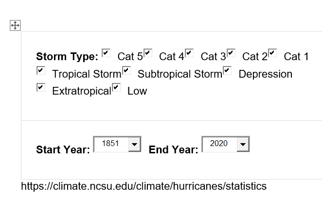
If the storms less powerful than tropical storms are removed from consideration, this is what the chart looks like for tropical storms and all hurricanes³⁸:

The graph above shows the total number of tropical cyclones affecting North Carolina by decade
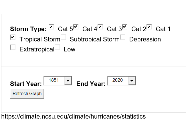
The State Climate Office of North Carolina removed these charts illustrating the decline in the number and intensity of hurricanes affecting North Carolina from its website since the publication of this author’s original article in 2021.
However, there were no hurricanes or tropical storms of a serious nature in 2021 so the information communicated by these charts remain the same.
Bringing the data closer to the Piedmont region, the following charts from the SCONC show the frequency and intensity of all storms categorized as “tropical storms” since 1851 and within 100 miles of the original State Capital at 1 E. Edenton Street in downtown Raleigh. This data contains reports of all storms with winds of 40 miles per hour or more, so includes all tropical storms and hurricanes within 100 miles of the Wake County area.³⁸

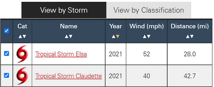
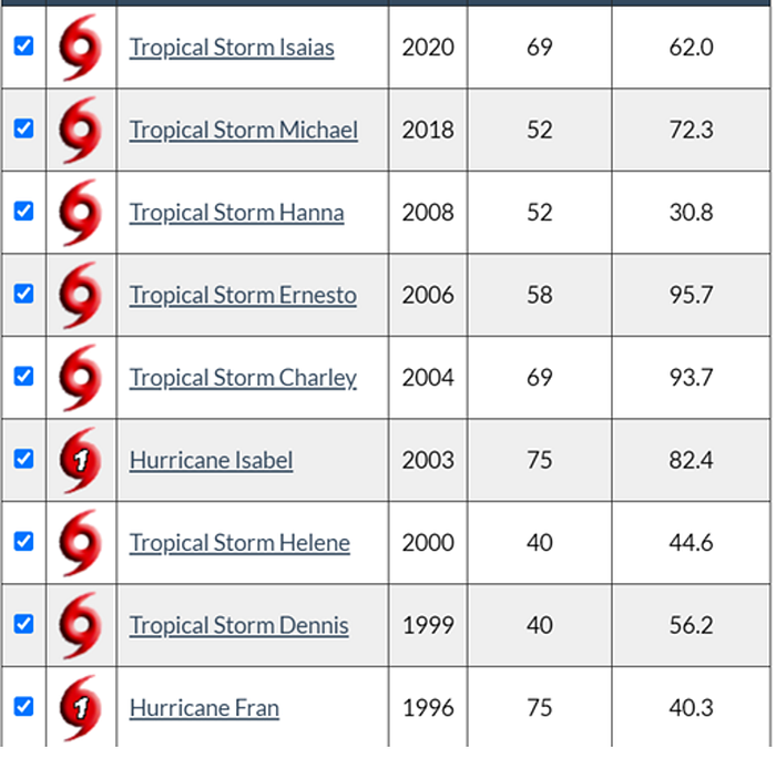
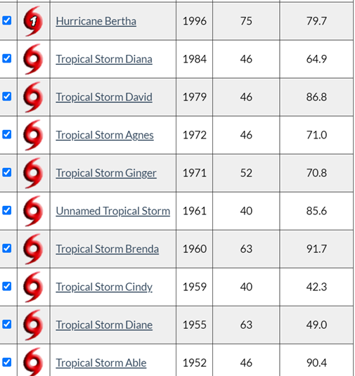
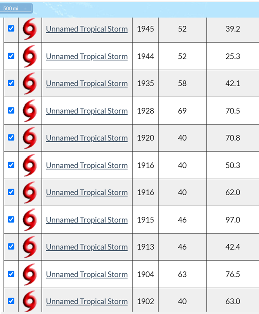

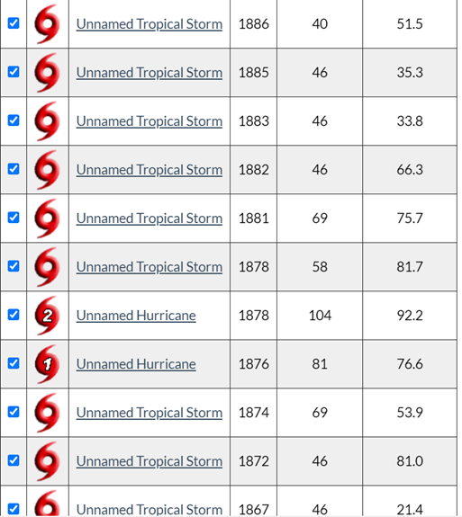

The above charts reflect that since 1851 the frequency of tropical storms and hurricanes within 100 miles of the Old State Capital in Raleigh has been as follows:
1992–2021: 3 hurricanes, 9 tropical storms
1962–1991: 4 tropical storms
1932–1961: 8 tropical storms
1902–1931: 8 tropical storms
1872–1901: 6 hurricanes, 20 tropical storms
1851–1871: 1 hurricane, 6 tropical storms (only 21 years)
Notable is the year 1893 which had four tropical storms, including a Category 1 hurricane. There have been only four tropical storms and no hurricanes in the past 10 years.
But some commentators have said that even if the hurricanes are less frequent, they have become more powerful. So, let’s look at the same history of tropical storms above, but set out and ranked by strength in terms of mile per hour winds.
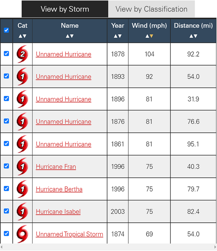

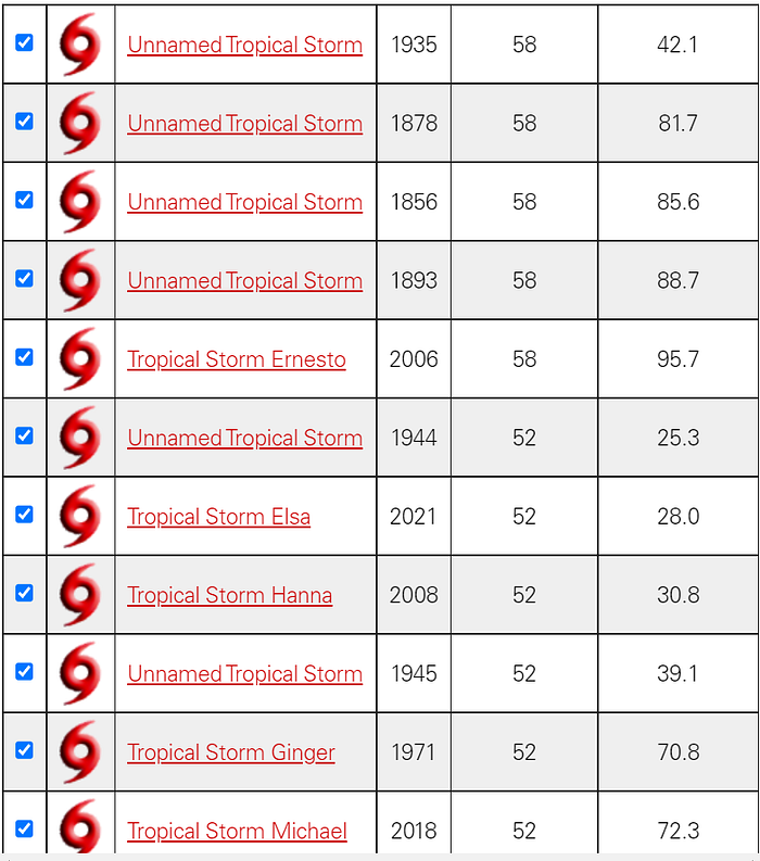
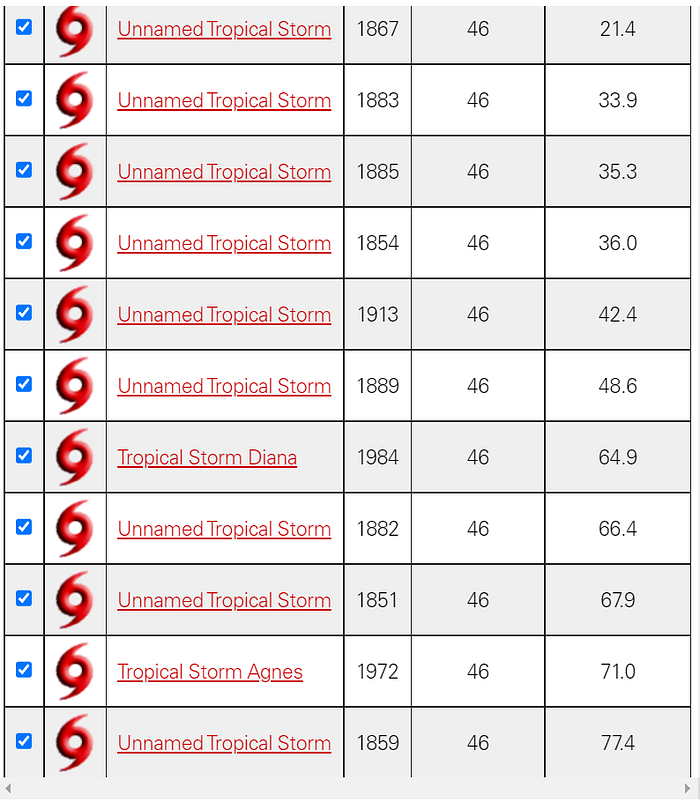


Placed in chart form, here is the above information.
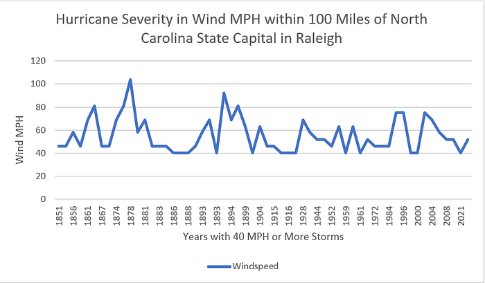
As shown above, for the past 171 years tropical storms and hurricanes in the Wake County area, and the state itself, have not been becoming more frequent nor more powerful in recent years. They were more frequent and stronger farther back in history.

SPRING AND FALL FREEZE DATES
All gardeners pay attention to freeze dates, especially the Spring freeze date (which in meteorological circles is referred to as the “last” freeze date and the Fall freeze date is the “first” freeze date). Gardeners’ Spring planting decisions revolve around the average last freeze date and impatient gardeners spend a great deal of money on early Spring plant purchases and make strategic decisions about moving plants from the inside, whether it be the house, garage or greenhouse, to the outdoors.
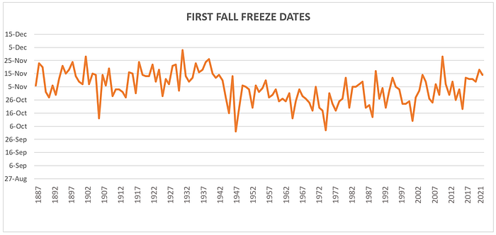
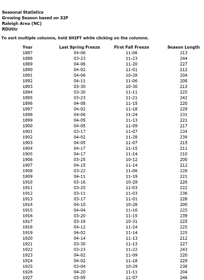
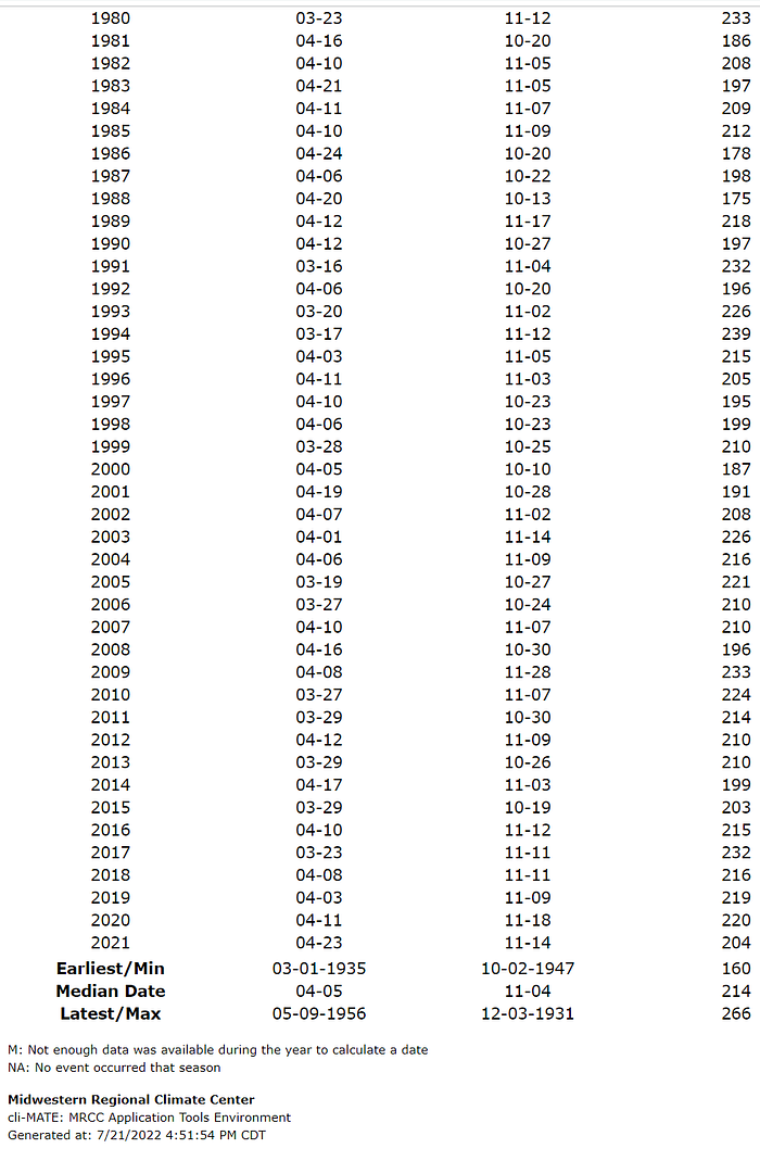
According to NOAA, the average Spring freeze date in Wake County and surrounding area, per the RDU station (1887–2021), is April 5th. The average Fall freeze date is November 4th.³⁹
The earliest last Spring freeze date is March 1st in 1935 and the latest last Spring freeze date is May 9 in 1956.
Here are charts depicting these dates over time, first for Spring through 2021 and then for Fall through 2021. To the extent that global warming advocates warn that the last Spring freeze date is, or will be, occurring earlier and earlier in an unprecedented manner as the growing season allegedly becomes longer, this is not borne out by the historical data which shows most of the earlier Spring freeze dates occurring in the first half of the last century. 2021’s last Spring freeze date was April 23rd, 18 days after the average date.

Similarly, the “first” Fall freeze date has not been delayed in a significant, enduring and unprecedented manner as borne out by the following chart.
Gardeners should be in trust but verify mode when presented with “average freeze date” calculations, primarily to ensure the information is the best available and applicable to their location. An example is a Wake County COOP type weather station which has been used to represent average freeze dates, the Falls Lake station, COOP id #312993, images and a description of which appear above in this article. While this station was first put into service in 2000, it is missing significant periods of data and has been situated in three different locations. The station did not start reporting data in years in which both the Spring and Fall freeze dates could be determined until 2009 and overall is missing almost 40% of the first/last freeze dates for the period from 2000–2021. It also failed to report any first freeze date for the Fall of 2019.
By contrast, the RDU station information yields data for each year since 1887 without any missing records, as seen below:

For those gardeners interested in determining freeze dates in your vicinity, you can consult the weather station at the nearest Primary Local Climatological Data Stations (see endnote 10) or at your nearest and largest airport since these are likely to have more complete data than other stations. In any event, freeze date and growing season information is easily obtained for any station by going to the climate center designated by NOAA as the lead agency for determining freeze dates at locations across the country, the Midwestern Regional Climate Center (“MRCC”): https://mrcc.purdue.edu/CLIMATE/index.jsp and see further details and instructions at endnote 39.
GROWING SEASON
The length of time between the two average Spring and Fall freeze dates is referred to as the growing season and its current average length in the Wake County and surrounding Piedmont area is 214 days.
Here is a decade-by-decade numerical summary of the length of the growing season since 1887:
1887–1891: 220
1892–1901: 224
1902:1911: 218.4
1912–1921: 224.2
1922–1931: 233.6
1932–1941: 238.8
1942–1951: 210.8
1952–1961: 206
1962–1971: 195
1972–1981: 190.6
1982–1991: 202.4
1992–2001: 206.3
2002–2011: 215.8
2012–2021: 212.8
The average length of the growing season in the past 30 years (212.8 days) is shorter than the historical average of 214 days and markedly shorter than the time period in the late 1800’s and the first half of the last century (for example from 1912–1941 the average length of the growing season was 232.20 days). So, the recent growing season is significantly shorter than the average during periods in the first half of the last century.
Here are these figures in chart form through 2021:

The chart illustrates that our recent growing season lengths are not unprecedented and are shorter than the majority of historical recorded periods.
GROWING DEGREE DAYS
Growing Degree Days (GDD) are used to estimate the growth and development of plants during the growing season. The basic concept is that development will only occur if the temperature exceeds some minimum development threshold, or base temperature (TBASE). Base temperatures are determined experimentally and are different for each plant.⁴⁰
Below is a chart of the GDD per RDU weather reports based on a 50° base temperature which is the base temperature for the following plants: Corn, Muskmelon, Pepper, Rice, Sorghum, Soybeans, Sweet Corn, Tomato and Snap Beans.

The average GDD per year from RDU records since 1887 is 4,825.96. A review of the last 30 years shows an average of 5,030.10 GDD per year, while a review of the 30-year time-period from 1912–1941 shows an average of 4,939.86 GDD per year. So, while recent GDD are above average, this is a trend similarly found in the early part of the 1900’s.⁴¹
CONCLUSIONS
The 2002 and 2015 reports on climate change in North Carolina conclude there are no significant, enduring and unprecedented statewide climatological trends that are associated with global warming. A third study in 2020 reported temperature trends in the Piedmont region reflective of global warming present in only some, but not most, temperature categories, with no increase in extreme weather events.
This article’s examination of average temperatures in the Wake County area in North Carolina’s Piedmont region found recent 30-year average temperatures rising, but in similar fashion of past periods, average minimum temperatures decreasing, and average maximum temperatures increasing, although periods of increase also occurring in the last century. While days with minimum temperatures of 75 degrees or more occurred more frequently than average in periods in both the 1900’s and this century, the only study to address the issue (the 2015 State Climate Office Climate Change Report) found that this only occurred in urban, nor rural, areas.
Looking at special categories of interest to gardeners (humidity, soil temperature, average freeze dates, growing season and growing days) reveals that there do not appear to be any abnormal and unprecedented trends occurring and if anything, seasonal coolness trends are indicated with a shortening growing season. To the extent there has been an increase in growing degree days, it is similar to increases during similar periods early in the last century. Extreme weather events such as 3” rains and hurricanes have not increased in frequency or intensity, with hurricane activity and intensity decreasing.
Whether any trends similar to those found in the past will continue or change remains to be seen, as does whether any new trends will develop. In any event, this article has provided a review of the historical climate of Wake County and the surrounding Piedmont region of North Carolina, and also has given gardeners a glimpse into how weather observations are collected and reported, as well as how to access this information.
By Tom Packer, Certified Master Gardener, Vice-President of the Gardeners of Wake County, Board Member of the North Carolina Cooperative Extension Agricultural Programs Foundation, Moderator of “Gardening Carolina” Facebook Group and longtime backyard farmer in North Carolina and Northern California. Other horticulturally related articles by Mr. Packer can be found at https://medium.com/@tpacker25. All this article’s content is that of Mr. Packer alone as an individual and not as a member of or on behalf of any organizations or groups with whom he is affiliated.

ENDNOTES
[1] https://drive.google.com/file/d/1MI4vnDo9vrH-YRSbwpIQqjhYnB5PnHeS/view?usp=sharing
[2] While the report mentioned a 2006 PowerPoint presentation by the then head of the State Climate Office of North Carolina, Sethu Raman, on reports from 10 weather stations, 9 of which were monitored by volunteers, on just two historical weather element observations until 2002, the final report did not include a historical study of the climate in North Carolina nor come to any conclusions as to whether global warming trends existed in the state. The report only noted: “… short-term trends indicate warming along the coast, cooling in central North Carolina, a deficit in precipitation in the northern coastal part of North Carolina, and an increase in precipitation in the southern part of North Carolina. Dr. Raman asserted that the density of climate observations needed to be improved in order to be confident about observed trends.” While the mean temperature results from nine of the 10 weather stations had some increases, some decreases and some basically remaining the same, one station in Elizabeth City was noted to have the most significant mean temperature increase. However, a review of the records from this volunteer citizen monitored station reveals hundreds of missing days of observations over the years, including, for example, 334 out of 365 days in 1951 and 158 missing days out of 365 in the concluding year of the study, 2002. Days with no temperatures reported at all occurred in 99 out of the 107 years of this COOP-type weather station’s operation. See: https://drive.google.com/file/d/1ANliQLiHdiStC2l5F38dSTpJbwhDqYzC/view?usp=sharing
[3] https://web.archive.org/web/20150420025024/http://www.nc-climate.ncsu.edu/climate/climate_change and https://drive.google.com/file/d/1Y4YgPJ7L0-YW7b3k1vGGTggEXw8AOCFs/view?usp=sharing
Note: This report was found in a website archive search site. It was captured by the website archive service on April 20, 2015 and prior dates. This report no longer appears on the website of the State Climate Office of North Carolina.
[4a] https://www.ncei.noaa.gov/access/metadata/landing-page/bin/iso?id=gov.noaa.ncdc:C00861;view=iso; https://www.ncei.noaa.gov/metadata/geoportal/rest/metadata/item/gov.noaa.ncdc:C00861/html
See, “Publications citing this dataset should also cite the following article: Matthew J. Menne, Imke Durre, Russell S. Vose, Byron E. Gleason, and Tamara G. Houston, 2012: An Overview of the Global Historical Climatology Network-Daily Database. J. Atmos. Oceanic Technol., 29, 897–910. doi:10.1175/JTECH-D-11–00103.1.”
[5] Personal communication with author — July 20, 2020.
[6] While the RDU weather station is a First Order station, identification #13722, according to a NOAA representative all major airport weather stations are also assigned a COOP station number, here, RALEIGH AP #317069, even if they are not COOP-type stations. So, there is only one weather station at RDU, it is a First Order station, and there is not a separate COOP station at the site.
[7] See, https://threadex.rcc-acis.org/ re NOAA’s ThreadEx records (click on “About.”).
[8] APPENDIX B — Accessing NOAA Daily Temperature and Precipitation Extremes Based on Combined/Threaded Station Records, NATIONAL WEATHER SERVICE INSTRUCTION 10–1004, MAY 17, 2020, “This new ThreadEx data set provides a consistent basis for the reporting of daily extremes for the longest period of time meaningful. With the ThreadEx effort, maximized, consistent, updated daily extremes will be available for government, partner, and general public (especially media) use.” And see, Yuchuan Lai, David A. Dzombak, Use of Historical Data to Assess Regional Climate Change, Journal of Climate, 10.1175/JCLI-D-18–0630.1, 32, 14, (4299–4320), (2019), citing Kunkel, K. E., D. R. Easterling, K. Redmond, and K. Hubbard, 2003: Temporal variations of extreme precipitation events in the United States: 1895–2000. Geophys. Res. Lett., 30, 1900, “The availability of these pre‐1948 daily data affords an opportunity to perform studies with unprecedented detail, extending back to the late 1800s of trends in short duration extreme events.”
[9] Use of Historical Data to Assess Regional Climate Change, Yuchuan Lai and David A. Dzombak, Journal of Climate, American Meteorological Society, July 15, 2019, pages 4299–4320, https://doi.org/10.1175/JCLI-D-18-0630.1
[10] NATIONAL WEATHER SERVICE INSTRUCTION 10–1004, MAY 17, 2020, Operations and Services, Climate Services, NWSPD 10–10, Appendix C. The other five Primary Local Climatological Data Stations (PLCDs) in North Carolina are Asheville Regional Airport (AVL), Hatteras Billy Mitchell Airport (HSE), Charlotte Douglas International Airport (CLT), Greensboro Regional Airport (GSO) and Wilmington New Hanover Airport (ILM). These stations are regarded as “Primary” because of the extensive and manual quality control checks they are subject to, which other weather stations are not. (Per communication with NOAA representative on April 27, 2021).
[11] http://xmacis.rcc-acis.org/ — Seasonal Time Series / Avg temp / Mean / por -2021 / Annual / Average of Months / Daily Station Selection 311535; https://drive.google.com/file/d/1aRgCC11HSWLXxs2OpcFXyueblKZUwHDb/view?usp=sharing
[12] http://xmacis.rcc-acis.org/ — Seasonal Time Series / Avg temp / Mean / por -2021 / Annual / Average of Months / Daily Station Selection 312993; https://drive.google.com/file/d/1M9SEL4rPxEigkh5hayiwCC_1I5_B3Hk2/view?usp=sharing
[13] Communication from NOAA representative with author on January 21, 2021.
[14] The station identified as 317069 NSW COOP Raleigh AP is not included in this count of COOP stations as this is, per endnote 6, First Order station KRDU #13722.
[15] See, https://www.ncdc.noaa.gov/homr/#
[16] Daly, C., M.P. Widrlechner, M.D. Halbleib, J.I. Smith, and W.P. Gibson. 2012. Development of a new USDA Plant Hardiness Zone Map for the United States. Journal of Applied Meteorology and Climatology, 51: 242–264 at 259.
[17] See: https://www.ncdc.noaa.gov/news/defining-climate-normals-new-ways
[18] See: https://drive.google.com/file/d/1MA7gw5GgsVCusiA8JwzZaUqvsFqRN6AV/view?usp=sharing and http://web.archive.org/web/20201114005450/https://planthardiness.ars.usda.gov/PHZMWeb/AboutWhatsNew.aspx
[19] After entering the site at http://xmacis.rcc-acis.org/, for RDU historical records, enter Single Station, Seasonal Time Series, the weather record and time-period and select the station by entering its id number, for example for RDU 13722 and choosing Raleigh area, or searching by location.
[20] http://xmacis.rcc-acis.org/ : single station/seasonal time series/ av temp/mean/ por — 2021 / Station: Raleigh Area/ RDU
[21] Temporal Variations of Extreme Precipitation Events in the United States: 1895–2000, Kenneth E. Kunkel, David R. Easterling, Kelly Redmond, Kenneth Hubbard, American Geophysical Union (AGU), GEOPHYSICAL RESEARCH LETTERS, VOL. 30, NO. 17, 1900, September 09, 2003. https://doi.org/10.1029/2003GL018052
[22] http://xmacis.rcc-acis.org/ : single station/seasonal time series/ min temp/mean/ por — 2021 / Station: Raleigh Area/ RDU
[23] http://xmacis.rcc-acis.org/ : single station/seasonal time series/ max temp/mean/ por — 2021 / Station: Raleigh Area/ RDU
[24] http://xmacis.rcc-acis.org/ : single station/seasonal time series/min temp/number of days/Threshold: ≥ 75°/ por — 2021 / Station: Raleigh Area/ RDU
[25] http://xmacis.rcc-acis.org/ : single station/seasonal time series/ precipitation/sum/ por — 2021 / Station: Raleigh Area/ RDU
[26] http://xmacis.rcc-acis.org/ : single station/seasonal time series/ precipitation/number of day/ equal to or greater than 1 inch/ por — 2021 / Station: Raleigh Area/ RDU
[27] http://xmacis.rcc-acis.org/ : single station/seasonal time series/ precipitation/number of day/ equal to or greater than 2 inches/ por — 2021 / Station: Raleigh Area/ RDU
[28] http://xmacis.rcc-acis.org/ : single station/seasonal time series/ precipitation/number of day/ equal to or greater than 3 inches/ por — 2021 / Station: Raleigh Area/ RDU
[29] http://xmacis.rcc-acis.org/: single station/seasonal time series/ snowfall/sum/ por — 2021 / Station: Raleigh Area/ RDU. Reported trace amounts were counted as .01 inches.
[30] http://xmacis.rcc-acis.org/: single station/seasonal time series/ snowfall/number of day/ ≥.1 inch/ por — 2021 / Station: Raleigh Area/ RDU
[31] This information formerly in 2021 was accessible at: https://climate.ncsu.edu/cronos/?station=KRDU&temporal=monthly%20Average%20Daily%20Relative%20Humidity/average/percent%20(%)/height%20%E2%80%93%202m . However, now it must be accessed after registration with the State Climate Office of North Carolina at: https://products.climate.ncsu.edu/cardinal/ The humidity readings obtained can be found at: https://docs.google.com/spreadsheets/d/1vgOLrMv4uhz2WWuOiuRgyC4M1nQ_Pbkl/edit?usp=sharing&ouid=115138207048984797333&rtpof=true&sd=true
[32] Communication with author on July 27, 2020.
[34] https://www.ncdrought.org/files/documents/2018_annual_report.pdf
[35] https://www.drought.gov/historical-information?state=north-carolina&countyFips=37183
[36] N.C. Drought Management Advisory Council Annual Report at https://deq.nc.gov/media/24612/open
[37] September 11, 2020 post on Nextdoor.com.
[38] https://climate.ncsu.edu/climate/hurricanes/statistics. While this particular bar chart has been removed by the State Climate Office of North Carolina from its website, its current search function for the same type of storms does not reveal any such storms after 2019: https://products.climate.ncsu.edu/weather/hurricanes/affecting/?state=NC&buffer=150
[39] https://mrcc.purdue.edu/CLIMATE/index.jsp
Daily observed data, Seasonal, Seasonal Statistics
Growing season/ ≤ 32°/1887–2020, Find a station, NC, ThreadEx/Raleigh Area (Station ID: RDUthr). Sign up for free account and sign in. Once logged in, change the daily station to KRDU at the top of the screen. Historical first and last freeze dates are located in the menu on the left under Daily-Observed Data — Seasonal- Seasonal Statistics. Select the Frost Season and if necessary, change the temperature threshold to ≤ 32°. NOAA has designated the Midwestern Regional Climate Center (MRCC) as the lead climate center for determining average freeze dates around the country.
[40] Definition per the MRCC.
